
iMapIt “turns” your iPhone / iPad into a GPS receiver that will collect geographical coordinates, wherever you are, to map, measure or simply record places important to you.
![]()
See how simple it is to map your terrain using iMapIt:
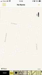
As soon as you open the application, this screen appears. At the bottom of the screen you will find a sliding menu that provides you with several options for the collection process. But the principle is: Position yourself at some point on the contour of your terrain and tap the “Start” button. Down there on the left.
When you tap the “Start” button, the yellow “MapIt” button appears inside the map, and you can start mapping.
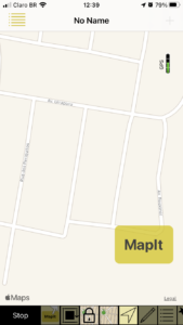
The action now is: each time you tap the “MapIt” button, iMapIt will collect the coordinate of the location you are in and begin to join these coordinates in a sequence, as you collect new coordinates.
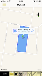
Outline your terrain by collecting these points. It is important to collect at least one new point at each change of direction, or at each vertex of your terrain. You do not need to go back to the starting point because, when you are finished, the last point will automatically be linked to the first, since we are mapping a terrain (closed polygon).
When finished, press the “Stop” button, which appeared in place of the “Start” button, and you’re done. There is your terrain mapped and measured.
IMapIt has several features to facilitate your mapping process
- Coordinate collections manually or automatically;
- Survey viewing on schematic map, as in the images above, or satellite photos;
- The map’s orientation can follow your displacement;
- Define or change each mapped item as a point, or a set of points, a line, or a polygon. Lines and polygons dimensions are automatically calculated for you;
- Metric, imperial or Thai units;
- Export of your complete project in DXF, KML, GPX or CSV formats;
- Export your project by eMail, send it to your site, or get it through your computer;
- Editing functions such as union of features, duplication, division, elimination of specific coordinates or “cleaning” of your collection;
Do you need more information on iMapIt?
We have a series of articles on our support blog and we chose to highlight some of these articles below to bring you some additional details:
Detailed information on iMapIt main screen – Map Screen
Features and comparison between versions
iMapIt Versions

This is the iMapIt full version. It has all the available features.

This is a trial version. With it you can test almost all of the iMapIt features, including the calculation of the area of your land. But only the first calculation. The export function is blocked.
This is a free version.
Up to this point the Pro and Lite versions are separate apps on the App Store. In this way it is not possible to exchange data between them. Thus, surveys made in the Lite version cannot be migrated to the Pro version and vice versa.
This is an application that is only available for Apple platforms, therefore only available for iPhones and iPads.